

Since 1931, Rugby, North Dakota has claimed this honor. They have a stone monument and everything. Rugby has a population of about 2,700 and is the county seat of Pierce County. Rugby was founded in 1886 at a junction on the Great Northern Railway, where a branch line to Bottineau met the main line.

The railroad promoters initially platted the town as Rugby Junction, getting the name Rugby from the town of Rugby in Warwickshire, England. It was one of several sites along the Great Northern’s transcontinental route between Devils Lake and Minot that were named after places in England

(the others were Berwick, Leeds, Knox, Norwich, Penn, Surrey, Churches Ferry, Tunbridge, and York). When the community became a city, the Junction was dropped from the name. So, how was it determined that this was the continental bull’s eye? Around 1930, an employee with the U.S. Geological Survey took a cutout of the map of North America and balanced it on the top of a pin.


Not the most sophisticated method but for decades few argued with it. Rugby embraced the designation. It gave this tiny dot on the prairie a true sense of place. Well, that’s all to this story … or is it? It seems there is a scientific claim to the center of North America that may hold some water.

Peter Rogerson Ph.D.[1], a professor of geography at the University at Buffalo in New York used new scientific methods and the azimuthal equidistant projection[2] to calculate the “geographic center” of the North American continent. By some extraordinary coincidence, he found that Center, North Dakota, is the continent’s geographical center. Rogerson is a SUNY Distinguished Professor in the Department of Geography in the UB College of Arts and Sciences and has an adjunct position in the Department of Biostatistics in the UB School of Public Health and Health Professions.
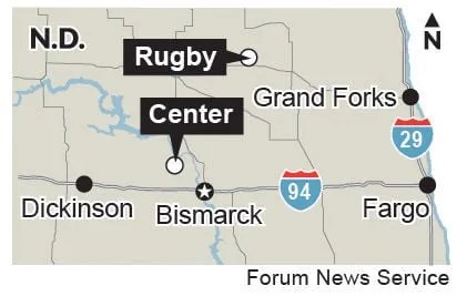
Center, is a city in Oliver County, North Dakota. It is the county seat of, and the only incorporated place in, Oliver County. The population was 588 at the 2020 census. The town is somewhat notable for the blizzard-related death of Hazel Miner, who would go on to be the subject of a song and memorials.
When I ran my computer program and looked at the final latitude and longitude, I was astounded to see that it was in a place called Center
Peter Rogerson

Another town, 100 miles south of Rugby, also tried to make claim to the center. One night in Hanson’s Bar, armed with a globe, some string, and more than a few beers, they made the case that the continent’s center was – perhaps not so coincidentally – right beneath the bar itself.

They checked to see if Rugby had trademarked their precious phrase “Geographical Center” – and it turned out they had or thought they had. They had let it lapse and three-hundred-and-some dollars later it belonged to Hanson’s Bar.

They later backed down, and gave the Geographical Center trademark back – to Rugby, although he’s still not removing the decal on Hanson’s Bar floor.

I don’t know the true center but I feel I must go with the Ph.D., the man using the scientific method and with no personal ties to the area. The USGS has no official definition of a geographic center and no agreed-upon method for determining it. The current center does not include islands in the Caribbean, which are part of North America. There is also no particularly compelling scientific reason to calculate or debate the point. It’s more of a matter of civic pride than scientific advancement.
Footnotes
- Among other topics, Rogerson has studied the mobility of the U.S. population, with some research examining baby boomers and how members of this generation have migrated and clustered within the United States. He has also applied his expertise to the fields of health and medicine, examining the impact of geography and other factors on the incidence of diseases including breast cancer. More recently, Rogerson has focused on developing new methods for the quick detection of emerging clusters in geographic data (for example, how does one determine as quickly as possible whether there is a new cluster of crime or disease?). Rogerson is a fellow of the American Association for the Advancement of Science and was a resident fellow at the Center for Advanced Study in the Behavioral Sciences at Stanford University. He has received numerous awards, including a Guggenheim Fellowship. Rogerson has published over 100 research articles on demography, statistics, and geography. He is also the author of “Statistical Methods for Geography” (Sage Publications, 5th edition), “Spatial Statistical Methods for Geography” (Sage Publications, forthcoming), and “Statistical Detection and Surveillance of Geographic Clusters” (CRC Press, co-authored with Ikuho Yamada, Ph.D.). Rogerson joined UB’s faculty in 1986 after working briefly in several other academic and professional roles, including as a research analyst for the New York State Office of Parks and Recreation; a biostatistician for the New York State Department of Health; a research associate on a special project on economic-demographic modeling jointly sponsored by the American Statistical Association, U.S. National Science Foundation, and U.S. Census Bureau; and an assistant professor in geography and civil engineering at Northwestern University. He received a BA from the University at Albany, an MA from the University of Toronto, and a Ph.D. in geography from UB. [Back]
- The azimuthal equidistant projection is an azimuthal map projection. It has the useful properties that all points on the map are at proportionally correct distances from the center point, and that all points on the map are at the correct azimuth (direction) from the center point. A useful application for this type of projection is a polar projection which shows all meridians (lines of longitude) as straight, with distances from the pole represented correctly. The flag of the United Nations contains an example of a polar azimuthal equidistant projection. [Back]
Further Reading


Sources
Smithsonian
CBS News
Wikipedia
University of Buffalo
